Crumbling levee triggers evacuations for small farming community in the Delta
- Share via
Evacuation orders were issued Monday for a small farming tract in the Sacramento River Delta after a compromised levee posed a risk of flooding the area.
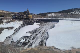
Battered by recent storms, the levee in Tyler Island, an area about six miles south of Walnut Grove in Sacramento County, began crumbling after a nearly 70-foot-wide hole developed within the structure, said Matt Robinson, a spokesman for Sacramento County Water Resources.
Because the levee could fail, county officials ordered voluntary evacuations for about 20 homes in the area. The National Weather Services also issued a flash-flood warning.
“Tyler Island is expected to flood due to a compromised levee,” the notice read. “Residents are strongly advised to leave for their safety.”
As of Monday afternoon, Robinson said residents had not evacuated the island.
The area’s reclamation district is working to reinforce the levee with rocks and boulders, he said.
“It’s an all-hands-on-deck type of effort,” Robinson said.
Surrounded by water from the Mokelumne River, the rural area is home to several produce farms, he said. Tyler Island is one of several communities in the Delta.
According to the U.S. Geological Service, a network of drainage ditches helps keep water levels in the islands 3 to 6 feet below land surface.
The flooding is not connected to the Oroville Dam situation, which triggered officials to evacuate more than 100,000 people due to concerns an emergency spillway could collapse.
Officials are trying to repair erosion at the spillway as well as the levee before the next storm on Wednesday.
The recent storms have replenished water in most of the state’s major reservoirs so much so that some are near capacity.
On Monday, the U.S. Bureau of Reclamation released more than 74,000 cubic feet per second from the Shasta Dam, increasing flow into the Sacramento River, according to the Shasta County Sheriff’s office.
“The releases are necessary in anticipation of the upcoming storm systems and to ensure adequate flood storage in Shasta Lake,” the sheriff’s office said in a statement. “Water levels will continue to rise and are expected to fluctuate as it takes time for tributaries and mountain runoff to reach the valley floor.”
Sheriff’s officials have closed access to the river due to the high water levels.
“High releases have caused localized flooding in many areas, as well as road closures throughout the county,” the sheriff’s office said. “The closure will be lifted as soon as it is safe.”
Twitter: VeronicaRochaLA
More to Read
Sign up for Essential California
The most important California stories and recommendations in your inbox every morning.
You may occasionally receive promotional content from the Los Angeles Times.


